October 21, 2021
It has been 10 days since I was able to post to this blog, so I will break it up into two separate postings.
We spent three days in the Moab, Utah area visiting Arches National Park (for half a day) and Canyonlands National Park - both quite crowded.
Driving into Arches, we expected a long line at the entrance gate. It took 10 minutes to get through the line, but only because the ranger wasn't checking passes or taking money, just waving cars through. During previous visits over the years, we never took the time to hike to Delicate Arch, the park's iconic formation ... too hot on our summer visits, too crowded a few years ago when we visited only for about an hour before sunset. We decided we had better do it this time before we get any older. It was not to be - the parking lot at the trailhead was full and the ranger was waving cars on by. We settled for a hike to a viewpoint to see it from a distance.
You can see people lined up to the left for their photo op under Delicate Arch.
After passing a few other full parking lots, we stopped at a few less crowded formations - plenty to see in this amazing national park.
Skyline Arch
Sand Dune Arch trail
Sand Dune Arch
Heading out of the slot canyon after seeing Sand Dune Arch
Double Arch - our favorite
Our main objective for this area was Island in the Sky unit of Canyonlands National Park. (We visited the Needles unit 3 years ago.) We saw interesting sights on BLM land on the way and spent three nights dry camping in a BLM campground just north of the park entrance.
Monitor and Merrimac Buttes on the way to Island in the Sky
4-wheel drive Shafer Trail Road access to White Rim Drive - not for us!
Shafer Canyon Overlook - Kris is bundled up after waking up to 27 degrees in the campground.
Looking through Mesa Arch to the Colorado River side
Brian enjoys the view
Tafoni along the Grand View Point Trail
(Known as honeycomb weathering or "swiss-cheese rock," tafoni (singular: tafone) are small, rounded, smooth-edged openings in a rock surface, most often found in arid or semi-arid deserts. They can occur in clusters looking much like a sponge and are nearly always on a vertical or inclined face protected from surface runoff. Source: nps.gov)
Green River side of Island in the Sky - this part of Canyonlands NP is where the confluence of the
Green and Colorado Rivers is found.
Looking east toward the LaSal Mountains
Views from the end of the Grand View Point Trail
As we exited Canyonlands National Park at 11:00 a.m. on our last day's visit, we counted 110 cars lined up to enter. Time to make our escape!
We left southeastern Utah and drove to Chinle on the Navajo Reservation to Canyon de Chelly National Monument for a guided tour of the canyon. Visitors can drive the scenic rim drives on their own, but can only visit the canyon floor with a park ranger or a Navajo guide. There are families who live and farm in the canyon and many sites have historic and religious significance. We reserved a guided tour before leaving home and were lucky to be the only two passengers along for the ride. The three-hour drive through sand and rock was quite bumpy, but we enjoyed the learning experience.


Harold, our driver and guide
Not the most comfortable-riding, but it got us through the soft sand and rocks on the canyon floor.
 |
| Driving through soft sand |
One of the several Anasazi cliff dwelling ruins
 |
| Sheer canyon wall |
Views from the rim drive:
The morning sun felt good!
Spider Rock still in shadow - too early in the morning for a nice photo
Before leaving the reservation, we visited two other National Park Service sites:
The trading post is still active - you can buy candy, motor oil, expensive Navajo baskets
and blankets, and various other goods.
Priceless Navajo rug on the floor of the Hubbell Home where Teddy Roosevelt
once stayed.
Betatakin Ruins at Navajo National Monument
This whole trip was planned around our desire to visit North Rim of Grand Canyon (we have been there only once before in 1991 with our four children) and the campsite availability before that part of the national park closes down for the winter at the end of October. We crossed the Colorado River on the Navajo Bridge and camped at Lee's Ferry in Glen Canyon National Recreation Area the day before our reservation at the north rim.
Historic Navajo Bridge on the left - we walked to the middle; current highway on the right
Not a bad campsite at Lee's Ferry with the Colorado River in sight
Colorado River near our campground
Balanced rocks on pedestals - Glen Canyon NRA
This one makes Brian look so small!
Stones enclosing a balance rock to make a shelter
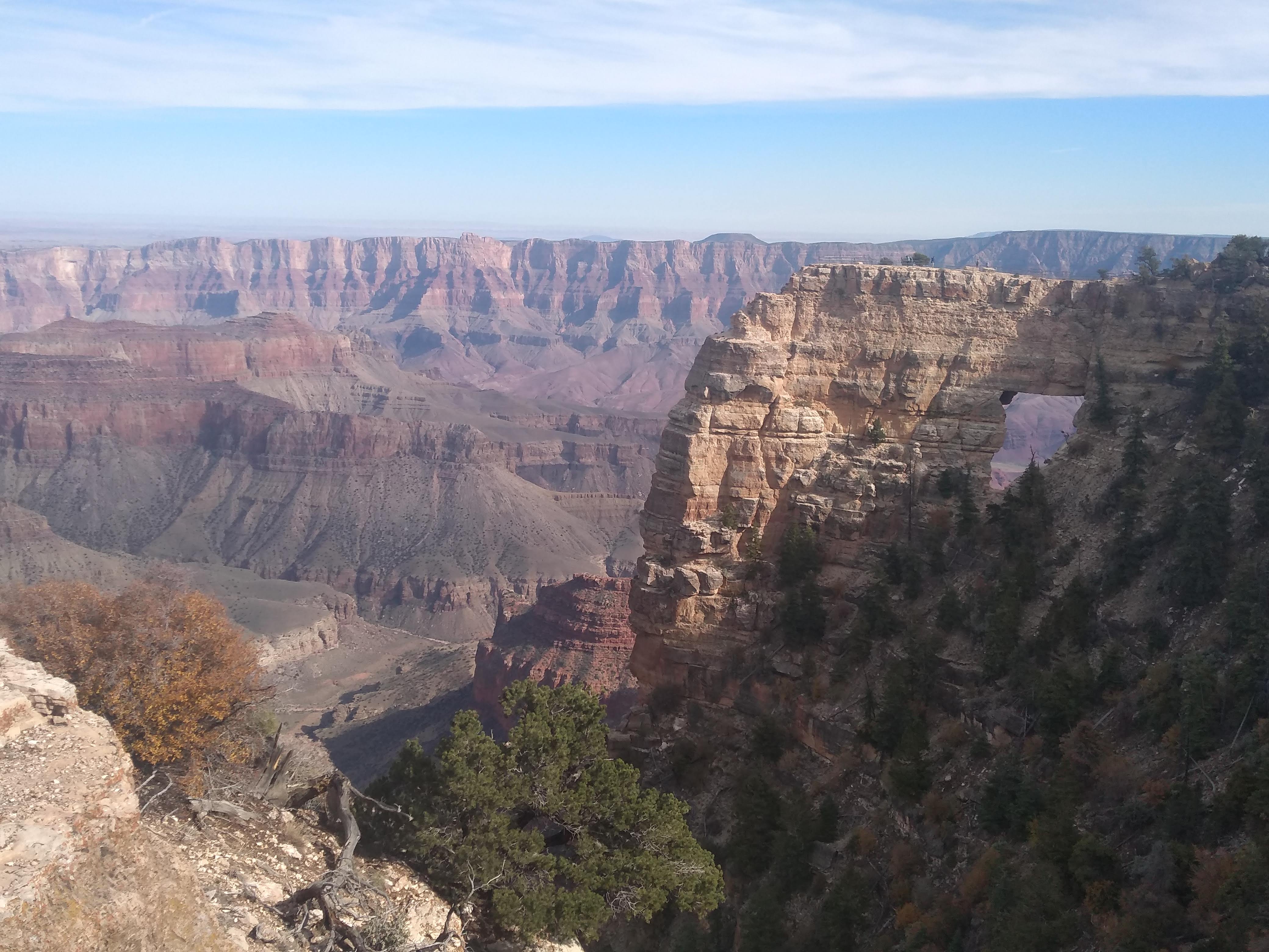
 |
| Angel's Window at Cape Royal |
 |
| North Rim |
Remnants of last week's snow on the north facing slopes
Bright Angel Point, North Rim
We had reserved two nights at the North Rim Campground, but we arrived early enough in the day to drive and hike to all of the scenic viewpoints on the rim drive. Also, the Visitor Center was already closed for the season so we left after one night.
Seen while geocaching:
Navajo Twin Rocks in Bluff, UT
Cemetery on hill above, Bluff, UT
Passing through Mexican Hat, Utah
John Wayne stayed at Gouldings' Trading Post and Lodge while filming
in Monument Valley
Not a geocache here, but an iconic film location.
We did not take a video of ourselves running in the highway as we saw other people doing.
Do you know what was filmed here?


No comments:
Post a Comment